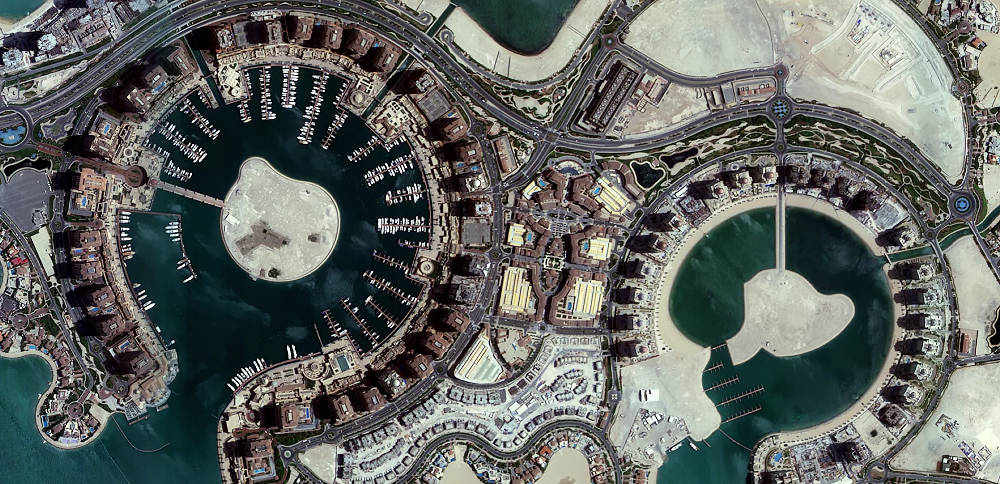
[A multi-spectral image of Doha, Qatar, taken on June 26, 2017, by Isro's Cartosat 2 series satellite. Source: Isro]
Within the span of a couple of days, India lost two stalwarts of its space programme, Prof. Yash Pal and Prof. UR Rao. This essay is a tribute to these exemplars, and the Indian Space Research Organisation (Isro) team whose efforts placed India on the centre-stage of earth observation—an important domain in space technology for an emerging economy like India. It provides valuable information on land use, ocean resource profile, and even enemy movement on the borders. In fact, Isro’s world class capability in earth observation, also called remote sensing, is probably one of its best kept secrets. India went from a novice to becoming one of the best in the world in about two decades.
Let us rewind to the mid-1970s. Prof. Pal was the first director of Space Applications Centre (SAC), and Prof. Rao was the first director of Isro Satellite Centre (ISAC). Prof. Pal seeded SAC with young scientists to work on satellite earth observation technologies for payloads—the scientific equipment on board a satellite. Prof. Rao’s team integrated these payloads to satellites. This combined Isro team took India to pole position in earth observation.
This was a result of the expertise and ingenuity of the Indian scientists. It was also a result of the meritocratic high-performance organisation culture in Isro that included a healthy collaboration among scientists from two different Isro organisations—SAC and ISAC. Last but not a least, it was a result of a culture of leaving important technical decision making to the subject matter experts irrespective of hierarchy. Technical excellence and an organisation structure conducive to technical excellence were nurtured by leaders like Prof. Pal and Prof. Rao. This was in the glorious tradition of Dr. Vikram Sarabhai and Prof. Satish Dhawan. Executives across the world recognise the importance of organisation culture and breaking of silos in the context of digital transformation. It appears that Isro mastered many of these aspects way back in the 1970s in the context of the earth observation programme.
The latest result of Isro’s technology innovation and culture is the successful launch and deployment of its latest earth observation satellite Cartosat 2E in June 2017.
It can capture more detailed images of objects on ground than India’s earlier earth observation satellites. This detail is measured in terms of spatial resolution—the minimum distance in metres on earth the satellite’s sensors can separate out and make visible to the eye.
Though it lags behind global leaders in terms of spatial resolution of the images, a simple comparison of spatial resolutions does not do full justice to Isro’s achievement. (See 'A primer on earth observation')
Indian earth observation technology included the entire gamut of designing the earth observation payload, integrating it on a satellite, launching the satellite (in recent years), transmitting the satellite image data to earth stations, and developing the IT systems to analyse this data. A cost comparison as per the Comptroller and Auditor General of India’s report in 2010-11 gives a good indicator of the immediate benefits—the price of comparable international earth observation data is six times the cost of Indian earth observation data.
Information from earth observation is used in improving accuracy of land records, crop yield estimation, forestry, etc. by various user organisations in India which are typically government organisations and departments. For example, crop yield estimation can improve the efficiencies in India’s agricultural forecasting and supply chain. An accurate forecast ensures optimum transport and storage resources are allocated. It also takes out some of the information asymmetry in forecasting pricing trends. In case of a severe shortfall in yield in specific crops in a particular region, state governments can be alerted to tide over the shortfall. In case there is pan-India shortfall in specific crops, the central government can be alerted to take steps to import. Timely information on country-wide shortages helps to make measured imports over a period of many months to avoid frantic last minute buying that usually spikes international prices.
The technology innovation
AR Dasgupta and Prof. S Chandrasekar have analysed the factors that led to the creation of India’s capability in their paper “Indigenous Innovation and IT-enabled Exports: A Case Study of the Development of Data Processing Software for Indian Remote Sensing Satellites” published by the University of Pennsylvania Institute for the Advanced Study of India. This is a fascinating story of how informed technology choice under favourable endogenous factors and exogenous factors led to innovation.
At the core of satellite earth observation are the satellite’s camera and sensors. In the late 1970s when Isro was assessing and planning for future earth observation satellites, the state-of-art technology for camera and sensor payload system was the American Multispectral Scanner (MSS) that was used in Nasa’s LANDSAT satellites.
MSS used discrete photodiodes—a device to convert light into electrical charge—as the underlying sensor technology. A set of discrete photodiodes formed a detector to capture information pertaining to four specific bands of wavelength for visible light. This meant that the camera had to be designed to split the light into four bands, and focus each band on the correct detector which required a complicated rotating scanning mirror.
That was not all. The scanning mirror had to be made out of beryllium. The technical expertise to fabricate high precision optical elements from beryllium was available only with a few organisations in the world in the late 1970s.
Isro scientists analysed the technology landscape, and inferred that in order to improve the spatial resolution the number of photodiode detectors had to increase significantly. This increase would pose challenges on the camera’s optical assembly and increase the size of the payload.
To sum up, the MSS technology was a complicated technology to work with, and the complexity would increase with improved spatial resolution.
Dr. George Joseph of the sensor development group in SAC was part of the study committee on Indian earth observation satellites led by Dr. TA Hariharan. Dr. Joseph first proposed the idea of using a Charge Coupled Device (CCD) sensor technology. The committee recommended the use of CCD technology integrated into a payload called linear imaging self scanning system (LISS).
CCD is a light-sensitive integrated circuit, and not an older generation device like the discrete photodiode used in MSS. Since CCD detectors were fabricated like integrated circuits, the Isro scientists felt that number of detectors/cost ratio would follow Moore’s law. CCD technology was also commercially available from many countries. This ensured that there would be no lock-in to a particular vendor.
The use of CCD technology would not only make it easy to increase spatial resolution, but also reduce the complexity of the camera optics. The complex beryllium mirror-based system of the MSS is replaced with a simpler lens-based system in LISS. It was proposed to use separate lens system for each band to reduce complexity.
However, to be fair, the choice of CCD detectors was not an “open and shut” decision. There were complexities in aligning all the separate lens systems for each wavelength band. This type of a system was never built in Isro or India before. However, the Isro scientists came to the conclusion that the CCD technology was the one for the future, less complex in the Indian context, and more amenable to indigenous development compared to MSS. In short, the Isro scientists believed that they could deliver on LISS.
Convinced by this team of specialist scientists, the Isro leadership decided to pursue developing the CCD technology. It took about a decade to perfect the payload, and IRS 1A was launched in 1988 with a LISS payload which provided a multispectral wavelength band spatial resolution of about 70m. It was probably the second earth observation payload in the world to use CCD technology. The French SPOT 1 satellite launched in 1986 was the first with CCD technology. Just in case anyone has doubts whether the Indian payload was inspired from the French, the answer is no. SPOT 1’s payload had a single lens optics even though it used CCD sensors, while the IRS 1A’s LISS has a multiple lens arrangement.
The pinnacle moment for Isro and India was when IRS 1C launched in 1995 with the LISS 3 payload with a spatial resolution of 23m that was among the best in the world. And a PAN camera that had the distinction of having the best spatial resolution of 6m in the panchromatic band (essentially black and white images) for a civilian satellite, which was bettered by IRS 1D launched in 1997 with a 5.8m resolution.
This numero uno position in panchromatic spatial resolution was maintained by Indian satellites till 1999 when the IKONOS 2 satellite was launched with a panchromatic spatial resolution of 1m.
What is heartening to note is an indigenous earth observation science and technology was powering this achievement, and was facilitated by favourable exogenous and endogenous factors. What were these factors?
A culture of fostering technology innovation
Space technology has always been a pride of place for Indians. From the 1970s, the Indian Prime Minister has almost always been the minister responsible for the Department of Space. Successive Indian governments have been benevolent in nurturing Isro, and have not micromanaged its technology management aspects. It is fascinating to study the endogenous factors that contributed to the successful development of the LISS payload.
First and foremost, Dr. Sarabhai, Prof. Dhawan, and their team of leaders like Prof. Pal, Prof. Rao, and Dr. K Kasturirangan have built a culture that nurtures technology innovation. It is a culture where technical meritocracy supersedes hierarchy. While the decision to go ahead with an earth observation satellite program in the late 1970s came from the top of the Isro hierarchy—notably Prof. Dhawan, then chairman of Isro—the decision on the choice of CCD technology was left to the most qualified scientists in this domain—Dr. George Joseph and Dr. Hariharan. The technology choice had the backing of leaders like Dr. Kasturirangan, Dr. Rao, and Prof. Pal. The best technology ideas won, and teams with differing technical opinions quickly buried their differences, united by the common overarching vision of making space technology relevant for India.
Another interesting aspect of Isro those days was that a strong team of technology planning and management experts—like Prof. S Chandrashekar and Dr. YS Rajan—were also part of the team working on specific mission mode programmes. They played an important role in managing the liaison with government departments outside Isro. They also ensured that the teams were not limited by internal Isro silos. For example, an important success factor for Isro’s earth observation mission was the collaboration between SAC and ISAC teams. The former designed the payload and the latter designed the satellites that carried the payload.
While the formal organisation structure of Isro on paper reflected a traditional bureaucracy, it was characterised by strong informal boundary-spanning networks of professionals in various organisations within Isro. This provided the nimbleness and flexibility to execute first-of-a-kind mission mode technology programmes. The organisation culture, structure, boundary-spanning, and coordination mechanisms in Isro were probably as good as the best technology and research organisations in the world at that time.
Is Indian earth observation a national system of innovation?
However, the pace of adoption of earth observation information among users—especially government agencies—was slower than what one would have expected. This is a result of unique institutional challenges that exist in India. While earth observation technology and its use cases have the elements of becoming a national system of innovation in India, it is still evolving to become one. A national system of innovation is a set of organisations that jointly contribute to the development and diffusion of technologies, provide a framework for policy to influence the innovation process both in supply and demand side, and the end users of the technology.
Some states like Karnataka and Andhra Pradesh started their journey to use earth observation data early and have made good progress. In fact, Karnataka State Remote Sensing Applications Centre was setup in 1986—even before IRS 1A was launched—to leverage information from the Indian earth observation programme. This has resulted in better geographical information systems that have enriched many e-governance programmes such as watershed development, town planning, and in forestry and agriculture. Other states have been slow to leverage earth observation information.
Technology innovations from national mission mode programmes like the Indian earth observation transform a nation when they march in step with the scale and scope of user adoption. In the case of Indian earth observation, the demand-side still has some catching-up to do with the supply-side to make it a national system of innovation that is an important contributor to India’s development.
A primer on earth observation
Earth observation is the science of deriving information about an object from measurements made at a distance from the object. In satellite earth observation, information on an object is obtained by measuring the light/radiation reflected and emitted by this object at different wavelengths from the ultraviolet to the microwave. Specially designed sensors placed on satellites detect this radiation.
The scientific equipment carried by a satellite to carry out specific functions e.g. sensors for earth observation is called the payload of a satellite.
The radiation data or earth observation data captured by the sensors is transmitted to earth stations where they are stored and processed to provide earth observation information. This information is analysed using special purpose IT systems called geographical information systems (GIS) to get information on land use, ocean resource profile, etc.
Most often the information is converted into images that can be used to quantify natural resources, monitor changes in resources, provide quantitative estimates about resources, etc.
The minimum distance on earth the satellite’s camera and sensor system can separate out in the final image, and make it visible to the human eye is the spatial resolution. State-of-the-art satellites today offer a spatial resolution of about 0.30m.
We use information from satellite earth observation when we use Google Maps, Google Earth, Uber, Facebook, etc. If you have used a map application in your smartphone, you are probably enjoying the products of earth observation. And recently, literally down-to-earth unsuspecting neighbour feuds appear to be tailor made for earth observation payloads!